
Natural Flood Management Seminar by Dr Ian Pattison

Seminar
Natural Flood Management in England
Dr Ian Pattison
Dr Ian Pattison is an Associate Professor at the School of Energy, Geoscience, Infrastructure and Society at Heriot-Watt University. Dr Ian spends a large amount of his research time in the field and around rural farms around the United Kingdom. He is interested in hydro geology and how human activity impacts the landscape.
Dr Ian Pattison – Heriot-Watt University
Natural Flood Management in England
This Hutton Club’s seminar focused on flood management, farm practices and how compacted soil can affect catchment areas and water runoff. This is crucial to understand, in order to reduce the severity of floods in rural England.
I really enjoy going to non-geology seminars. They keep things interesting and allow a good insight into how other subjects do research. In this case the subject focused on farm surveys, hydrogeology and how different farming techniques have an effect on the drain off of the landscape. It turned out that where one places the sheep, horses or the chicken on land, that has an effect how the land drains, therefore how often it floods.
Examples of the sites he studied
Most of the sites Ian looked at are in the North of England and in the Home Counties. This is expected as one would have been quite alarmed if Ian would have started talking about the middle of Birmingham or London. By the laws of the City of London only a limited few can drive their livestock across London Bridge. So it is highly unlikely that the sheep trampling the ground could cause London to flood.
On the serious note, Ian looked at rural farms in Yorkshire, lying on the traditional floodplains around the rivers: Skell, Sense and Leic. (These catchments were traditionally dominated by agriculture since the medieval period.) His focus was on farms with livestock rather than cash crop farms. He also ran a few studies at forested areas such as Plynlimon in mid-Wales. He was curious how forest cover would effect the drainage of the land.
Ian also set up a study of farms around Barnard Castle. There is a possibility that the area has the capability to cure blindness. The catchment area might chemically alter the properties of the water. There is a stream in the area called St Cummings. [Joke]
Beavers and their impact on the landscape
Ian explained that in recent years it became popular to have natural processes maintain the landscape. He argued that modern English farming removed too much of the natural landscapes and intruded too deep into the once natural flood plains. Henceforth English farmers should reduce the size of their farmable landscape.
On the other hand he argued that farmers place too much of an emphasis on natural solutions to prevent flooding. They put too much of their trust in beavers for example. (I always knew that the Beaver Beliebers had something wrong with them!)
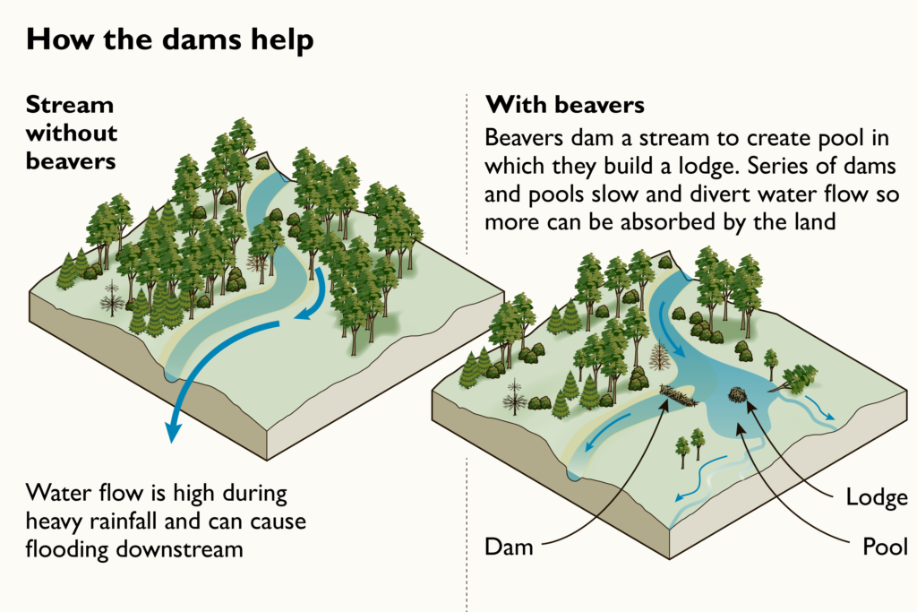

Beavers play a role but this is a very simplistic view of what happens with the landscape
He explained that beavers are seen as this fix all solution. When in reality the creatures are quite unpredictable and can cause as much flooding as they prevent. However he does argue that woody dams, brought together by natural timber either artificially or by a small beaver population, will ‘slow the flow’ of water, reducing the possibility of flooding.
How was the research carried out?
It was done by short term methods and long term methods.
There were regular farm surveys to see land use. Samples were taken to labs to see soil types and level of compaction. The soils of the entire farm were studied including the soils bellow the pens of the livestock.
How the livestock is moved around the land of the farmer was studied in detail as well. This allows an understanding of the hill-slope connectivity (how much the soil is trampled on a large scale so how easily the water moves across the landscape) and channel connectivity which looks at if there are any stream in the area if there is a proper flow of water above ground. The project looked at soil properties
The impacts of soil compaction were examined in arable landscapes by looking at how it affected the hydrogeological processes.
The volume of water flow in rivers was monitored along with the moisture levels of the nearby soils. This enabled an understanding of how much water gets stored up in the soil over time and on average how much water is the soil likely to hold.
The long term monitoring looked the historical record of flooding and compared with modern data.
All this was added together to get a complete idea of the soil profile of the catchment area. Zones of compaction to be identified from soil mapping and made into a handy map with red zones being the highest of risk (or the most vulnerable) and green zones being the lowest of risk (therefore need less careful management to prevent flooding).
Anyway, the main aim of the study was to identify the challenges the farmer will face when trying to solve the problem of flooding on their property.
This video explains how soil surveys are done, what are the key elements and how soil interacts with cash crops:
Comparisons in how the landscape is managed
Ian looked at how landscape management happens across the different farms. The key aim of his research is to figure out how to control floods and low flows.
One of the ways farmers work with the landscape is they recruit with natural processes by reforesting key areas with a landslide hazard, reducing the load of livestock on the fields and allowing a greater degree of biodiversity of animals and plants. The farmers also work to preserve the natural direction of streams and catchment areas rather than trying to take complete control over the hydrology of the area.
Most modern farming techniques try to acquire as much capital out of the land as possible, neglecting the natural processes that overlay the land. This leads to flooding and soil erosion.
To sum up:
Compaction->Soil Properties-> Hydrology
How soil compaction effects flooding
This was the weirdest part of the seminar, but at the same time a good example why details matter and why a tiny change in the data point can affect the wider outcome of the proceedings of events in a natural system.
One of the key elements of water drainage is how compact the soil is. If porosity and permeability are low the water travels on the surface washing away the soil and the property of the farm owner.
Soil gets compacted by livestock trampling it. While for a normal observer a herd of cows steping on the ground means nothing, and even silly to suggest that it causes flooding, just imagine the same herd doing the trampling every day for years and years. All of that adds up! The trampling create heavily compacted layers in the soil which prevent water draining into the landscape. The water after a heavy rain just runs across the fields, collecting up in the valleys.
Different animals compact the soil at different rates, with the heard size and pen location being a key factor as well. Different areas compact differently at different agricultural locations.
A butterfly flapping its wings can create massive storms on the other side of the planet. Those storms might rip Donald Trump’s wig off his scalp, sending him into a rage which might cause him to order a nuclear strike. Little events can cause low probability eventualities. (If you don’t believe me, hold my bleach for COVID19!)
This video gives a good context on what the farmers have to deal with on a yearly basis:
The non importance of farms to the economy
Ian argued that while farms play a big role in rural economies, they are not a big part of the UK’s GDP. They don’t employ a wide range and volume of people. They need EU subsidies to turn a profit and take up land that would be more valuable as development land for housing due to the UK’s housing crisis and to reduce high property buyers for first time buyers.
However farming is part of the UK’s cultural identity and while farms are small part of the overall economy (In 2019, Agriculture contributed £10,408 million or 0.53% to the national economy (Gross Value Added), an increase of £633 million (6%) on the year), they contribute 50-60% of the income of some rural economies. On a country wide scale farms are seen as unimportant:
However on a Council district levelk they are important as key sources of employment, votes and tax revenue for the local authority.
The methodology of the research (Identifying the scale of the field survey, the challenges involved with gathering the data and on what scale should is the data relevant to the farmer?)
Key elements of the research have been explained above, however for a farmer concerned with the productivity of his farm they are only concerned with one key goal: to lower the probability of flooding and reduce its magnitude as much as possible, thenceforth lowering costs as much as possible. Their two aims are to reduce flooding and increase the productivity of their agriculture.
The key person in this is the farmer who would commission the soil compact survey. The surveys and the reports need to be written in a way for farmers and managers to understand them. In some cases when local government is involved, the data and conclusions need to be translated in a way so that Council Officers and Councillors understand them and can incorporate it into Council policy.
How the data is interpreted is important as well and the scale of the interpretation. A good example from the lecture is how big one defines the size of the catchment area as the volume of water changes either at the start of the stream or at the later section. If you get the volume of water that passes through the area, wrong, flood prevention measures won’t work as they won’t be placed at the risk areas. (A big example being the beavers and letting the beavers alter the landscape on their own habitat needs.)
In some cases the catchment areas overlap so the study needs to focus on catchment scale impact on the soil compaction, changes to soil saturation and a study targeting subcatchments.
Fallacies about Natural Flood Management
Ian explained that some farmers saw the management technique as magic. That once it is implemented, it will eliminate almost all flooding. Yes… that is not how the real world works (For example Germany’s EU will not give us a better trade deal by reminding them that we won the the War in 1945, well we didn’t, it was the USSR and the USA that did 80% of the fighting, but hey, Rule Britannia!). So he broke down some of the fallacies of NFM:
Only works in small catchments. NO it can be applied across entire farms.
Beavers do help. NO it needs to be targeted.
Everybody can do it. NO it needs to be with a university and coordinated between farms.
Provides multiple benefits. NO it can cause harm if not properly done.
Key ideas from the seminar.
More compacted soils lead to greater flooding, therefore the location of the farm animals needs to be well managed. The soil compaction around their pens need to be monitored. This monitoring needs to happen with every farm in the area.
Different agricultural practices and different areas compact the soils more than other, therefore a diverse use of the land is needed.
Different animals compact the soil differently and they need different sized pens. This has an effect on the hydrology as there is different water content so different levels of flooding. Dependent on the level of soil compaction the water will drain through the land at a different speed.
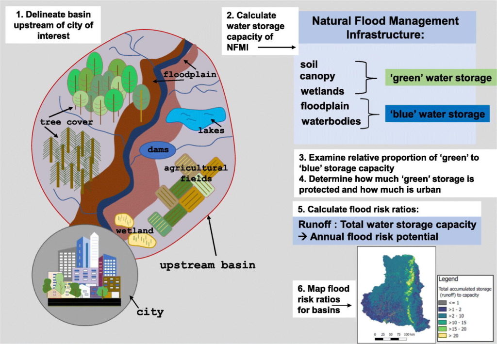

This is from the paper: Evaluating natural infrastructure for flood management within the watersheds of selected global cities – It explains the large scale steps needed to prevent high possibility of flooding around the UK
Helping rural communities to learn how to use fields properly will reduce flooding, helping to prevent economic damage in rural zones.
The Aim of the survey should be to reduce flooding, increase the productivity of agriculture and reduce long term financial damage to the UK’s rural zones.
The Key Ideas by Dr Ian Pattison
He runs an excellent twitter page where Ian presents his university work and gives snippets of his presentations.
Here he gives key facts about soil degradation in the UK and his conclusions from it:
Soil degradation causes economic damage on a considerable scale:
How the soil is compacted is a key element as it leads to flooding:
In order to fix the above problems, he came up with 3 key conclusions.
Where you put your animals and what types of animals you have, present a key factor in soil compaction as their trample the landscape differently:
Little areas add up when instead of individual farms entire catchment areas are surveyed:
If a single farm does good soil management, that is not enough, it needs a regional startegy:
Ian is indeed a source of wisdom:
His tweets at GowitheF1ow give a nice insight into the life of a soil scientist:
Dr Ian Pattison (@GoWithTheF1ow) / Twitter
References
Information for the entire blog is from the paper:
Dadson, S. J., Hall, J. W., Murgatroyd, A., Acreman, M., Bates, P., Beven, K., Heathwaite, L., Holden, J., Holman, I. P., Lane, S. N., O’Connell, E., Penning-Rowsell, E., Reynard, N., Sear, D., Thorne, C., & Wilby, R. (2017). A restatement of the natural science evidence concerning catchment-based ‘natural’ flood management in the UK. Proceedings of the Royal Society A: Mathematical, Physical and Engineering Sciences, 473(2199), 20160706. https://doi.org/10.1098/rspa.2016.0706


Comments
Post a Comment